


On the way to Ocracoke
On Wednesday, the main goal was to drive to Ocracoke Island and back. Basically, it takes a few hours to drive to Hatteras Island and then you have to wait for the next ferry. You can see on this map that I borrowed from a site on Outer Banks Restaurants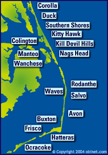
approximately how far it is in between Nags Head and Ocracoke, even though there isn't a scale. Keep the eastern edge of North Carolina in mind when you're looking at this and maybe that will help. As you drive south, you pass through the towns listed on the map, which are all comparatively small. Otherwise, one is driving through coastal wildlife refuges and there is pretty much nothing there. I got the impression that as you go south, toward Hatteras, the towns are ritzier. Most of the houses in Avon and Hatteras are huge and gorgeous. There are neat areas where there is water between the road and the houses on the sound side, so the houses look as if they were actually on the surface of the water and there are slightly arched bridges from the road to where the houses are. Next time I should really take some pictures of this, because it looks really wild. At night, on the way back, the lights were reflecting in the water, so it was really beautiful.
Once we got to Hatteras, we had to wait for the ferry for an hour and a half. We really had no idea when we were going to be about to board one, but we feared it would take a while, because there were so many cars ahead of us. It was warm and fairly excruciating, but my dad and I had been making up flash cards so I could study for the ham radio General exam, to upgrade my license, so it was somewhat productive. The ferry ride itself lasts about 40 minutes and was kind of fun, since we were actually moving. One cool thing is that the guy in the vehicle to our right, once we got on the boat, was a ham from Winston Salem.


No comments:
Post a Comment
Note: Only a member of this blog may post a comment.